Water Management in the Face of Extreme Rainfall and Climate Change
The accumulated experience with tailings dam failures and instabilities in waste rock piles converges on an uncomfortable, yet inescapable, conclusion: containment structures generally do not fail because…the safety factor was low on paper."They fail because water, in its different forms, has not been treated as a strategic risk variable. Reservoir levels operating near freeboard, unmonitored pore pressures, drainage systems designed for a climate that no longer exists, underestimated surface and internal erosion, spillways sized based on partially outdated historical data. The pattern repeats itself."
At the same time, the hydrological regime that underpinned intensity-duration-frequency curves, design floods, and traditional concepts of "extreme events" is no longer stationary. In several mining regions in Brazil, the observed reality is a higher frequency of very intense precipitation events, a greater concentration of volumes in short time windows, and greater interannual variability. In other words, more critical events, more abrupt and less predictable by historical statistics.
In this context, the paradigm of “meet the standard and the minimum safety factor."This becomes insufficient. Operators who truly want to reduce structural risk need to migrate from a point-in-time, static drainage model focused on isolated works, to a water resilience model. In this model, tailings dams, stockpiles, pits, processing plants, and intake and discharge systems are treated as a single system, managed under explicit scenarios of climate change, hydrological uncertainty, and increasing pressure from investors, regulators, and communities."
Water as a critical risk variable
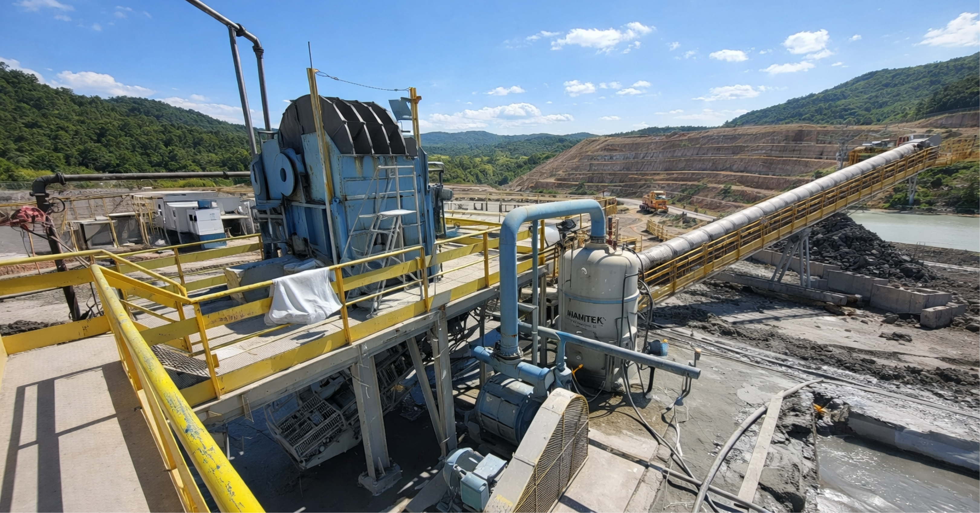
From a geotechnical point of view, water is the variable that connects virtually all relevant failure modes in rock piles and tailings dams. In terms of rock mass behavior, it modulates the stress state, the degree of saturation, suction in partially saturated zones, and pore pressures at critical interfaces. In hydraulic terms, it controls internal gradients, seepage, seepage, pipingSurface and internal erosion. In operational terms, it determines the effective freeboard, the hydraulic capacity of spillways and channels, the load on sedimentation basins, and the interaction with natural drainage systems.
In a typical tailings dam, intense rainfall and pressured operating conditions result in three risk fronts. The reservoir may experience a rapid rise in water level, consuming freeboard margins and bringing the system closer to overflow. The dam and foundation may experience increased pore pressure, displacement of the water table, and saturation of zones that, under service conditions, contributed to suction and additional resistance. The discharge system may operate above its designed capacity, generating localized overflows, abutment erosion, and unforeseen flow paths.
In piles, the dynamics are different, but the risk vector remains water. Prolonged rainfall events increase infiltration, raise the saturation front in internal zones, increase the acting self-weight, and reduce resistance at interfaces between materials with contrasting permeabilities. At the same time, the energy of runoff on extensive slopes intensifies erosion, generates deep gullies, carries large volumes of fines, and accelerates the clogging of channels, culverts, and dissipation basins. Structures originally designed as "support drainage" become critical points in extreme scenarios.
By placing water in this central position, the debate ceases to be merely hydrological or hydraulic. It becomes, essentially, a problem of integrated geotechnical risk and the allocation of capital to mitigation measures.
Climate change and extreme events
A large part of the tailings dams and tailings piles in operation today were designed under an implicit assumption of stationarity. The basic hypothesis was: the statistical past reasonably represents the future. From this hypothesis, intensity-duration-frequency curves, design return periods, spillway dimensioning fills, and freeboard criteria were defined.
The problem is that this premise no longer holds up comfortably in several mining regions. Certain combined patterns are being observed with increasing frequency. Events with return periods estimated in decades, according to historical statistics, are beginning to occur at intervals of just a few years. Rainfall volumes that were previously distributed over weeks are now concentrated in 24 to 72 hours, generating significantly higher peak flows for the same monthly or seasonal rainfall. Extremely dry years alternate with exceptionally rainy years, forcing the same system to operate under both extreme scarcity and extreme excess.
From a technical standpoint, this implies revising central design assumptions. Intensity-duration-frequency curves calculated solely based on long historical series can mask recent intensification trends. Design floods associated with return periods of 50 or 100 years may not adequately reflect current risk, especially when they do not incorporate extreme value techniques and climate scenarios. Concepts such as Maximum Probable Precipitation cease to be merely a regulatory requirement for dams with high damage potential and become a useful reference for testing the robustness of drainage systems in sensitive projects.
In practice, the operator who continues to design and make decisions solely based on historical data is accepting to run their business with an increasing level of uncertainty. And, often, without knowing exactly where the new boundaries of safety and failure lie.
Structural implications for TSFs in more extreme rainfall regimes.
When observing a radioactive stream (RTS) system under the lens of a more aggressive climate, three structural elements deserve special attention: the reservoir, the embankment, and the discharge and diversion system.
In the reservoir, the combination of intense events with operations generally under pressure to maximize water reuse and volumetric capacity results in increasingly narrow freeboard margins. A single high-intensity event in a few days can consume a large part of this margin, especially if the pumping and recirculation system does not have the capacity to quickly lower the level or if the operation works close to the approved volumetric limit. The central risk ceases to be just the design flood and becomes the sequence of events, the reservoir's starting level, and the system's response speed.
In the rock mass and foundation, the challenge lies in the hydraulic and geotechnical response under transient loads. Tailings with contractile behavior and low relative density are sensitive to abrupt increases in pore pressure and stress paths that bring them closer to static liquefaction. Horizontal drains, toe filters, crest drains, and other elements designed in the project may be partially clogged or underperforming as expected, resulting from fine deposition, variations in particle size distribution, or insufficient maintenance. Under extreme events, the system as a whole may respond very differently from that predicted in analyses. steady-state.
In the discharge and diversion system, the problem is less visible, but equally critical. Diversion channels, spillways, dissipators, and transition devices were often designed considering smaller contributing basins, lower sediment loads, and original cover and roughness characteristics. Years of operation, vegetation suppression, access road construction, and stockpile expansion alter the local hydrology. In extreme events, the combination of higher flow and higher sediment load quickly exceeds design capacities. The result can be overflow at fragile points, regressive erosion, loss of lateral containment, and, in more severe scenarios, the onset of erosion failures on abutments or the crest itself.
Structural implications for fuel piles in high rainfall regions
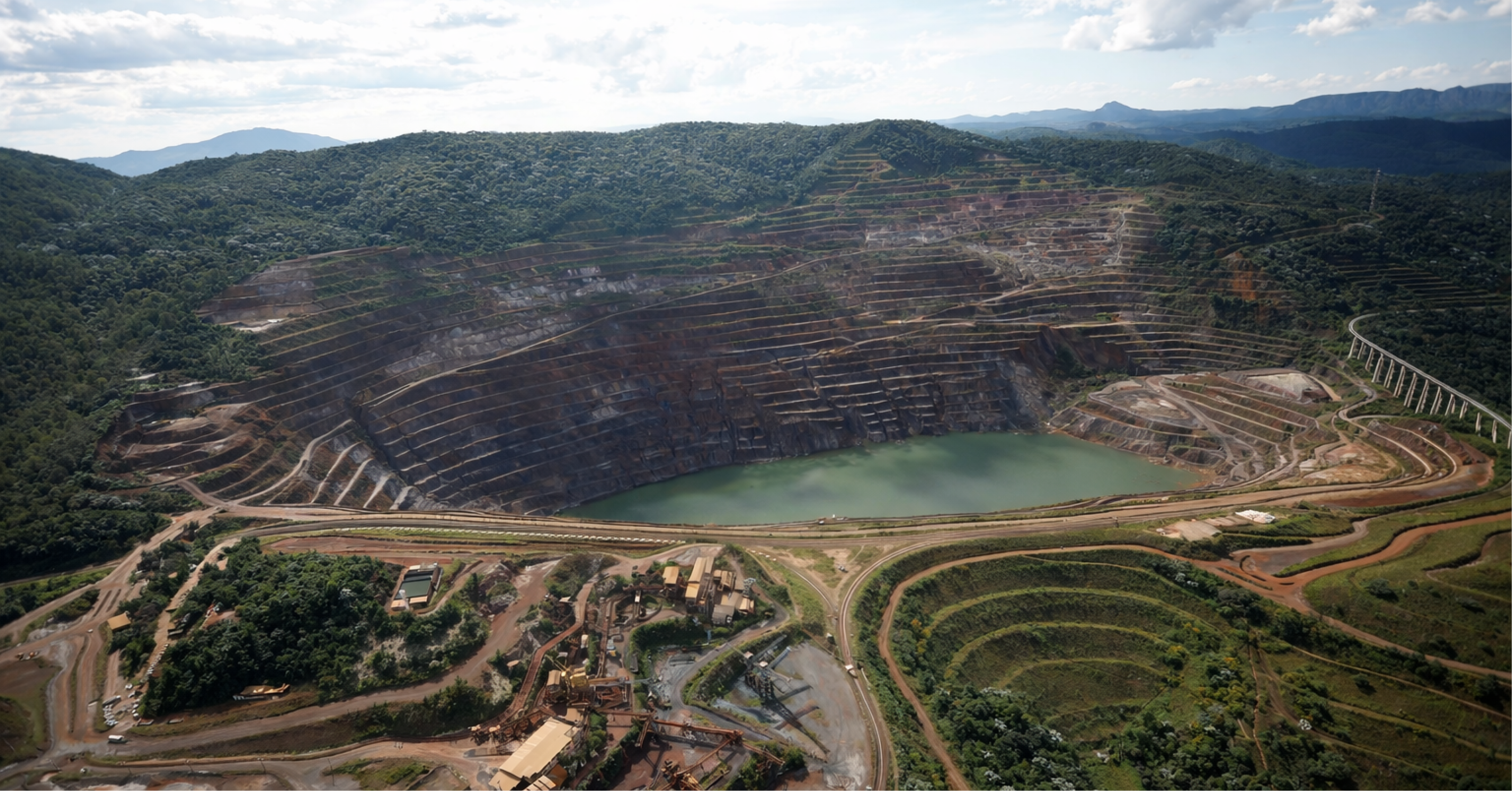
Waste rock piles, especially in regions with high rainfall and rugged topography, present a combination of risks that is still underestimated in many portfolios. They accumulate large volumes, significant heights, extensive surface drainage structures, and often foundations with residual or colluvial soils that are sensitive to saturation.
Surface erosion is often the first sign that the system is out of balance. On extensive slopes, even small concentrations of flow can evolve into deep gullies when subjected to high-intensity rainfall. These gullies expose inner layers, redirect runoff, destabilize berms, and carry large volumes of fine material. The resulting sediment load tends to rapidly clog channels, culverts, and sedimentation basins. With each event, the useful drainage section is reduced a little more, which worsens the behavior in the next event. The cycle is cumulative.
Infiltration and internal saturation are another significant risk factor. In piles with heterogeneous materials, preferential flow planes form along contacts between materials with different permeabilities. Under prolonged rain, these planes become zones of high pore pressure, close to potential rupture surfaces. In foundations with low drainage capacity, accumulated water can generate base settlement, slope rotation, and a progressive reduction in the safety factor. In many cases, the pile was designed assuming predominantly unsaturated behavior, with a significant contribution from suction. This contribution disappears under saturation, reversing the safety logic conceived in the design.
The sum of these effects creates an asymmetrical risk profile. The system operates, for much of the time, with an appearance of acceptable stability. However, in high-intensity events, especially those that occur after prolonged rainy periods, the behavior enters a different regime, closer to a limit condition. Without instrumentation and models that capture this state, management operates practically blindly at these times.
From “sufficient” drainage to water resilience.
Responding to this context with the traditional logic of simply increasing diameters, uniformly raising freeboards, or adopting arbitrarily longer payback periods is a partial strategy. It increases CAPEX without necessarily maximizing risk reduction per unit of investment. International experience in climate adaptation in mining suggests another path, based on four pillars:
- The first axis The goal is to treat the water balance as a decision-making model. This implies integrating, within a single framework, water that enters through rainfall, external intake, and water contained in ores and tailings, with water that leaves through evaporation, disposal, reuse in processes, and infiltration into containment structures. This model needs to be dynamic, fed by field data, and capable of simulating short-term scenarios, such as three days of intense rainfall, and long-term scenarios, such as seasonal and climatic projections. The objective is no longer just to show “balance sheet closing"For licensing and operational purposes, the goal is to anticipate bottlenecks, identify minimum safety margins, and guide daily and seasonal decisions."
- The second axis The goal is to design drainage systems for robustness, redundancy, and tolerance to degradation. Robustness means sizing for realistic extreme scenarios, with updated intensity-duration-frequency curves, use of extreme value techniques, and, when relevant, consideration of maximum probable precipitation. Redundancy means providing more than one safe runoff route for critical events, so that the partial failure of an element does not automatically lead to loss of control. Tolerance to degradation means assuming, from the design stage, that there will be clogging, increased roughness, and progressive loss of capacity, and incorporating sedimentation basins, inspection points, and maintainability windows into the design.
- The third axis The goal is to integrate hydrology, hydrogeology, and geotechnics into a single cycle of modeling, monitoring, and review. Isolated analyses, where a hydrological model produces peak flows, a seepage model calculates gradients, and a stability model assesses safety factors, tend to miss important nuances. The most robust approach is to couple these dimensions in a coherent, preferably probabilistic, chain calibrated with instrumentation. This includes piezometers, flow meters, pluviographs, surface benchmarks, and remote monitoring technologies such as InSAR and LiDAR. With each cycle, the models are updated and the risk scenarios are reviewed, reducing the disconnect between "model" and "field reality."
- The fourth axis The goal is to incorporate water management in tailings dams and tailings piles into risk governance and the corporate climate agenda. In companies with mature governance, water issues in containment structures reach the boardroom, with explicit indicators, risk maps, and mitigation plans. Climate adaptation plans cease to be generic documents and become prioritized portfolios of investments in drainage, monitoring, structural reinforcement, and operational strategy changes. Investors and insurers begin to demand concrete evidence, not just declarations, that critical structures have been tested against plausible future climate scenarios.
Vulnerability archetypes in high rainfall regions
When observing the behavior of landfills and piles in high rainfall regions, certain vulnerability archetypes appear recurrently, and it is worthwhile to treat them as patterns to be managed, not as exceptions.
A first archetype is the internal basin. These are small contributing basins, often associated with pile slopes, operating platforms, or access roads, that respond almost instantaneously to intense events. The local drainage system was designed as “assistant”, with modest sections, and becomes the point of greatest concentration of water energy. In extreme events, these points generate deep erosion, break lateral channels, and can direct flows to sensitive regions of the TSF or the tailings dam.
A second archetype is the chronically silted drainage system. Channels, dissipators, and sedimentation basins receive sediment loads far exceeding design assumptions, either due to the extent of exposed slopes or the absence of effective upstream erosion control measures. With each event, the usable volume decreases slightly, the roughness increases, and the effective overflow level drops. The system apparently functions well until the event that leads to the critical combination of high sediment load, high flow rate, and already elevated initial level.
A third archetype is the silent reconfiguration of natural drainage pathways. The sum of embankments, cuts, logistics platforms, roads, and stockpile expansions, over the years, gradually diverts water from original basins to artificial basins. Under normal conditions, the system absorbs these changes. In extreme events, the water “rediscovers” old valleys, overcomes small ridges, and flows along paths that converge at stockpile toes, TSF abutments, or unprotected areas. In many cases, the drainage maps used in the original project no longer represent the actual hydrology.
A fourth archetype is the poorly drained internal plateau or depression. Flat or slightly concave areas, in TSFs or piles, often intended for operational purposes, accumulate significant amounts of water during intense events. Without structured drainage, this water remains for extended periods, leading to saturation of surface layers, the formation of unforeseen percolation paths, and eventually, localized erosion processes that evolve into structural problems.
Practical agenda for operators
Migrating to a water resilience model in hydroelectric power plants and tailings dams is not just a matter of technical compliance. It's a lever for reducing operational and reputational risk, with a direct impact on CAPEX, OPEX, present value of contingencies, and cost of capital. A pragmatic way to organize this transition is to work in structured cycles.
The first cycle is the integrated water risk diagnosis. In this cycle, the company consolidates, in a single map, TSFs (Transferable Hydroelectric Plants), tailings piles, pits, drainage structures, catch basins, and sensitive downstream points. It compares design assumptions with observed data, identifies instrumentation gaps, maps structures operating with reduced margins, and classifies criticality based on damage potential, exposure to extreme events, and management maturity. This exercise generally reveals that the portfolio of critical structures is smaller than the total universe, allowing for more focused investment targeting.
The second cycle involves a climate and hydrological review of the design and operation parameters. The company updates intensity-duration-frequency curves with more recent data, assesses sensitivity to different return periods, tests scenarios using extreme value techniques, and, when relevant, incorporates regional climate projections. From there, it revises minimum freeboard, spillway capacities, channel sections, and reservoir operating criteria. It's not just about increasing numbers, but about understanding where the structure is already robust and where it is exposed.
The third cycle is the re-engineering of drainage and control systems. Based on the identified gaps, the company redesigns, reinforces, or complements channels, culverts, dissipators, sedimentation basins, and diversion systems. It introduces redundancies where there is currently a dependence on a single element. It creates safe overflow routes that prevent erosion at sensitive points. It adjusts access points and platforms to reduce flow concentration in critical zones.
The fourth cycle involves strengthening the water balance and instrumentation. The company implements dynamic water balance models, integrates rainfall, flow, level, pore pressure, and deformation data into operational dashboards, defines quantitative triggers for changes in operating regime, and activates response plans. During the rainy season, it adopts enhanced monitoring regimes with higher reading density and clear decision-making protocols.
The fifth cycle is integration with governance and external narrative. Technical results are translated into risk maps, indicators, and mitigation plans that can be discussed in risk committees, boards of directors, meetings with regulators, and dialogues with communities. The message shifts from "we comply with current regulations" to "here is the evidence that we tested our structures against plausible future climate scenarios, and here are the specific measures we adopted."
How does VinQ position itself in this context?
To operate safely in a regime of more extreme and uncertain rainfall, it is not enough to have good, one-off projects. It is necessary to build a water management system that connects field decisions, technical models, risk governance, and stakeholder expectations. It is precisely at this point of intersection that VinQ positions itself.
VinQ supports operators in building integrated water risk diagnoses for tailings dams and tailings piles, with a special focus on high rainfall regions. It develops water balance models that go beyond licensing and support real-time operational decisions and medium-term investment decisions. It redesigns drainage systems focusing on robustness, redundancy, and maintainability, considering the reality of climate change and increasing regulatory pressures. It integrates hydrological, hydrogeological, and geotechnical analyses into frameworks consistent with contemporary risk management standards, such as GISTM and international best practices.
More than just delivering isolated models or reports, VinQ works to ensure that water management in tailings dams and stockpiles is treated as a structuring axis of asset safety, operational continuity, and the social license of mining. In an environment where extreme events cease to be distant exceptions and become part of the relevant set of scenarios, this shift in focus is not only desirable. It is a condition for the business to continue existing with predictability and legitimacy in the long term.
Authors:

John Paul dos Santos
Bachelor in Mining Engineering (UFMG), Master in Civil Engineering and Management (University of Glasgow), Specialist in Geotechnical Engineering and Project Management.
Mining Engineer specializing in geotechnics and project management, an international reference in dams and geotechnical structures applied to mining.

Matheus Vicentini
Civil Engineer (Unilavras), Specialist in Geotechnical Engineering (PUC Minas).
Civil Engineer with experience in geotechnics applied to mining, with experience in projects, audits and dam decommissioning works.