Geometric adhesion and Catch Benches as a safety barrier: the impact of maintenance on risk reduction.
Advanced technical foundation based on the LOP Project guidelines and ISRM recommendations.
Introduction
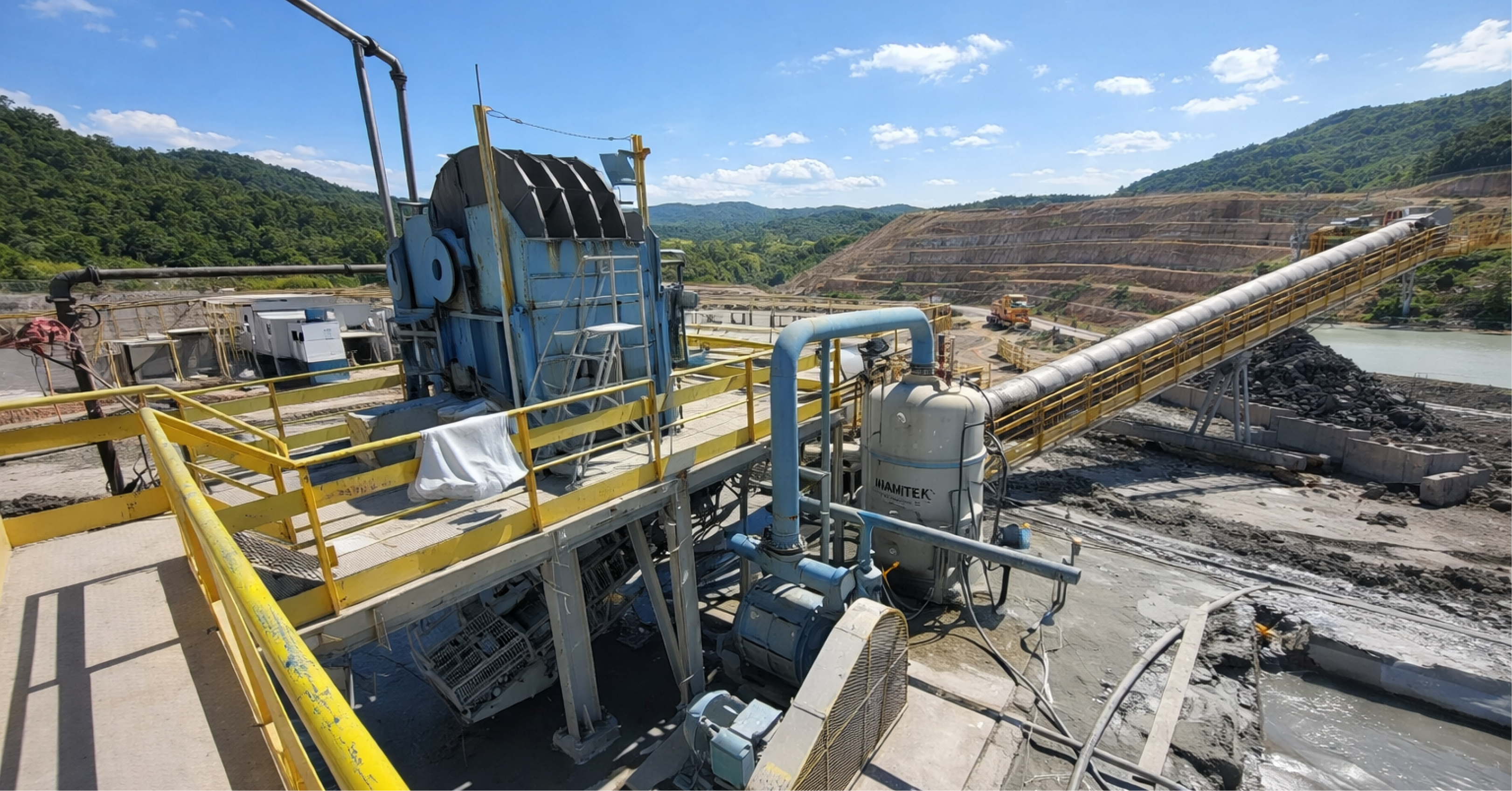
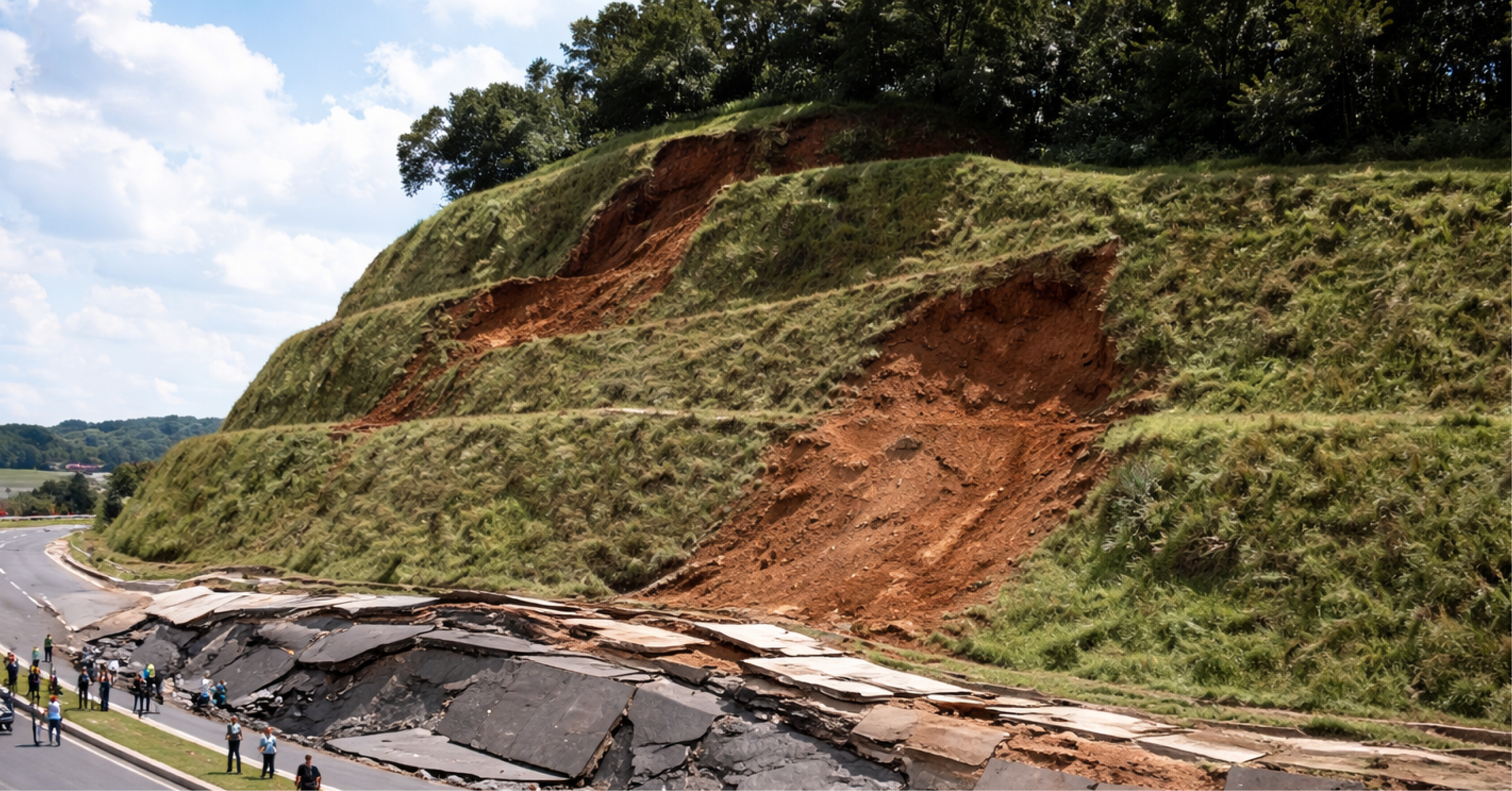
In open-pit mining, retention berms (catch benchesThese are consequence and exposure controls. They do not "prevent" the geomechanical event, but they reduce the likelihood of a local rockfall evolving into a serious accident by intercepting, dissipating energy, and retaining debris, as well as decoupling the propagation of events between banks. In practical terms, catch bench It is a critical passive barrier within the rockfall risk management system.
The central point advocated by best practices from LOP and ISRM is straightforward: the performance of this barrier depends on geometric adherence over time, that is, on how well the "as-built" geometry and, especially, the "as-maintained" geometry remain compatible with the profile and design intent during the operational life of the slope. The trap is well-known: designed berm ≠ existing berm. This difference almost never appears as a "sudden failure"; it sets in as cumulative degradation and becomes a silent hazard.
Geometric deviation: the incongruity between design, execution, and operation.
Geometric adherence can be understood as an index of conformity between designed parameters and parameters measured in the field: width, slope, clearance height, face angles, platform thickness/regularity, and surface drainage condition. The deviation between the model and the actual result generally arises from the overlapping of the following factors:
1- Limited precision in disassembly and overbreak/underbreak control.
Irregular road surfaces increase the "bouncing/flying" component, alter trajectories, and raise the demand for road retention on the berm.
2- Progressive deposition of talus and fragmented material
The buildup "steals" usable width and often creates an informal ramp that facilitates rolling and increases reach.
3- Surface erosion and gullying on the berm itself
When water finds its way over the berm, the berm ceases to be a barrier and becomes a channel. Gully erosion also creates grooves that "guide" blocks.
4- Unforeseen traffic and operational interventions
Heavy equipment, temporary storage, operational shortcuts, and makeshift drains degrade geometry and continuity.
5- Local settlements and deformations
Even without global instability, plastic deformations of the base material and "settlements" reduce headroom and alter drainage.
6- Lack of preventive and corrective maintenance routines
The berm doesn't fail for a single reason. It fails because there is no consistent mechanism to bring the geometry back to the design requirement.
The result is a cumulative process: the barrier loses resilience, the rockfall risk management system loses effectiveness, and the operation becomes dependent on luck, not control.
Why the impacts are greater than they seem.
It's common to overestimate. catch benches such as "geometric details," when in practice they influence multiple components of risk:
- Loss of volumetric and energy retention capacity (less usable width and less headroom).
- Increased reach of blocks through the creation of talus ramps and face irregularity.
- Change in trajectory regime (rolling → bouncing → flying), increasing exposure below the bank.
- Alteration of surface drainage, intensifying erosion and geometric deterioration.
- Difficulty of access for inspection and response, increasing the correction time and widening the exposure window.
- Secondary faults: critical segments induce propagation to adjacent berms (operational domino effect).
Important: Not every impact translates directly into a "decrease in global safety margin." The berm is, above all, an operational barrier, and its degradation usually manifests itself first as increased exposure and loss of consequence control capacity.
Geometric adherence metrics: measuring what truly controls risk.
Geometric fit needs to become an auditable KPI with consistent definitions. A minimum, robust package includes:
Fundamental metrics
(1) Effective Berm Width (EBW or Wₑ)
Useful horizontal distance for retention, discounting slopes, deformations, obstacles, improvised ditches, and operational use. Wₑ is what “remains” for retention.
(2) Clear Height (CH)
Vertical difference between the berm platform and the toe of the slope above. AL controls storage, interception, and dissipation capacity.
(3) Occupancy Rate (OR)
Percentage of width occupied by loose material/debris. A practical and often effective threshold is TO ≥ 30% as an intervention trigger, adjusted for criticality and local history.
(4) Profile Deviation (PD)
The difference between the projected 3D profile and the "as-built/as-maintained" profile, extracted from high-resolution DTM/MDS (LiDAR, photogrammetry, point cloud). DP is the objective "gap" between the model and reality.
(5) Berm Continuity (Cᵦ)
Percentage of bank length where Wₑ ≥ Wₘᵢₙ. Continuity matters because failure occurs in the worst segment, not the average.
(6) Geometric Deterioration Index (GDI)
A composite metric that weights deviations in Wₑ, AL, DP, TO, continuity, and drainage. The goal is to prioritize decision-making and maintenance, not to produce a "pretty" number.
Critical tolerances and acceptance criteria
Tolerances should be a function of: risk class, people-at-risk, operational criticality, and expected block drop mechanisms. As a conservative governance rule, negative variations greater than ~10% in critical parameters (e.g., Wₑ and AL) already warrant classification as non-compliance, with a correction deadline defined by exposure.
Measurement methods: the engineering of "as-built" and "as-maintained"
Geometric adherence requires measurements that are compatible with the criticality of the sector:
- Terrestrial LiDAR and photogrammetry with UAVs (drones) for point clouds and high-density DEMs.
- Differential GNSS and robotic total stations for topographic monitoring and frequent reconciliation.
- Point cloud processing for systematic extraction of Wₑ, AL, DP, and non-conformity maps.
- Integration into GIS or geotechnical platform for time series, heat map and prioritization.
The classic blind spot is treating surveying as "monthly" and inspection as "visual." In critical areas, the correct question is: what frequency keeps degradation within the acceptable window before it becomes an exposure?
Inspection and monitoring of degradation: layered protocol and trend analysis.
The inspection should be structured across multiple fronts, with traceability and a clear role in the decision-making process.
Layers of verification (defense in depth)
Layer 1 — Operational routine (daily/shift in critical areas)
Binary and objective checklist: bottlenecks, ramp, piped water, high TO (Total Operation), recent rockfall.
Layer 2 — Structured geotechnical inspection (weekly/bi-weekly)
Application of a checklist based on ISRM best practices, with georeferenced photographic documentation and criticality classification.
Layer 3 — Topographic reconciliation (monthly or by phase advancement)
Comparison of "design vs. reality," extraction of design data, Wₑ and continuity data, generation of a non-conformity map.
Tier 4 — Independent audit (quarterly/semi-annually)
It verifies the method, consistency of triggers, evidence, and effectiveness of the corrections.
Precursor signs with predictive value
Typical indicators of functional loss of the shoulder blade:
- Wₑ reduction below the limit;
- Increased occurrence of higher energy/volume blocks;
- Ravines crossing the verge or recurring flash flood;
- Longitudinal settlements and plastic deformations;
- Invasive vegetation indicating a lack of maintenance;
- Abrupt variations in humidity and surface resistance (when monitored).
Time series analyses and multivariate regressions can enhance maturity, but the real gains come from something simpler: consistently measuring and acting on triggers, without subjective debate.
Triggers for reprofiling and cleaning: quantitative criteria and decision flow
A trigger that isn't quantitative turns into negotiation. A robust set of "action triggers" includes:
- Wₑ < Wₘᵢₙ in any verified segment, especially under relevant exposure;
- TO ≥ 30% (adjustable by sector), indicating loss of usable width;
- DP exceeding the tolerated level by more than 20% of the bank length, suggesting loss of continuity and performance;
- Rockfall events with energy exceeding the design baseline scenario;
- Signs of settlement/disintegration detected in high-density topography or inspection.
Prioritization by criticality
The decision-making flow should incorporate a criticality matrix, combining:
- Exposure (people-at-risk, routes, active fronts);
- Potential severity (height, probable energy, range);
- Probability (trend of degradation, rain/disintegration, historical data);
- Responsiveness (access, operational window, resources).
This coupling avoids a common mistake: fixing "where it's easy" and not "where it's critical".
Governance: dealing catch bench as a critical barrier, not as a "routine service"
Operational maturity appears when the company deals catch benches How critical barriers are implemented and how barrier governance is applied:
- Clear performance requirement (Wₘᵢₙ, AL, continuity, functional drainage).
- Defined verification (who measures, how they measure, minimum evidence).
- Standard deadlines for correction based on criticality.
- Post-intervention acceptance criteria (how to prove that it has become a barrier again).
- Institutional learning: recurrence becomes root cause analysis (dismantling, water, operation, maintenance).
Here's the hard part: if cleaning and reshaping keep getting pushed back, it's not "lack of time." It's a governance failure. And the opportunity cost is operating with increasing exposure until the event.
Final considerations
The geometric adhesion of catch benches It is a pillar of operational safety in open-pit mines. The difference between the design geometry and the existing geometry is not a detail; it is the difference between having a functional barrier and having only a design. Robust technical metrics (Wₑ, AL, TO, DP, continuity, IDG), layer inspections, trend monitoring, and quantitative triggers for intervention form the minimum set to sustain performance over time. Without this, the berm ceases to be a defense and becomes a latent risk.
Authors:

John Paul dos Santos
Bachelor in Mining Engineering (UFMG), Master in Civil Engineering and Management (University of Glasgow), Specialist in Geotechnical Engineering and Project Management.
Mining Engineer specializing in geotechnics and project management, an international reference in dams and geotechnical structures applied to mining.

Leandro Azevedo da Silva
Bachelor in Geology (UFRRJ), Master in Mining Engineering (UFMG) and Specialist in Mineral Resources Engineering.
A geologist with nearly 20 years of experience in geotechnics, he leads technical projects at VINQ, combining innovation and safety in mining solutions.