From Data to Decision: Limits and Potential of INSAR in Tailings Dam Management
Risk governance in tailings dams is rapidly shifting from a model based on minimal compliance to one oriented towards performance, transparency, and enhanced accountability. Recent international standards for containment structures require operators to objectively demonstrate that they understand the behavior of their dams over time, that they understand their critical failure modes, and that they have mechanisms for early detection and structured response.
In this context, InSAR (Interferometric Synthetic Aperture Radar) has become established as one of the symbols of “new generation"Monitoring," often associated with terms like digital transformation, mining 4.0, and geotechnical monitoring centers. Technology, however, is only one component. Without an architecture of decisions, processes, people, and integration with other lines of evidence, InSAR risks becoming an expensive, visually impressive product with little relevance to the decisions that truly matter.
This article discusses the role of InSAR in tailings dam management through four central lenses: where the technology actually creates value in decision quality, what its physical and operational limitations are, how to integrate it with instrumentation, modeling and governance, and what operational model companies need to build for InSAR to move beyond the "color map...and become a critical risk management asset.
Why is everyone talking about InSAR in mining?
The promise: broad coverage, fine granularity, and low intrusion.
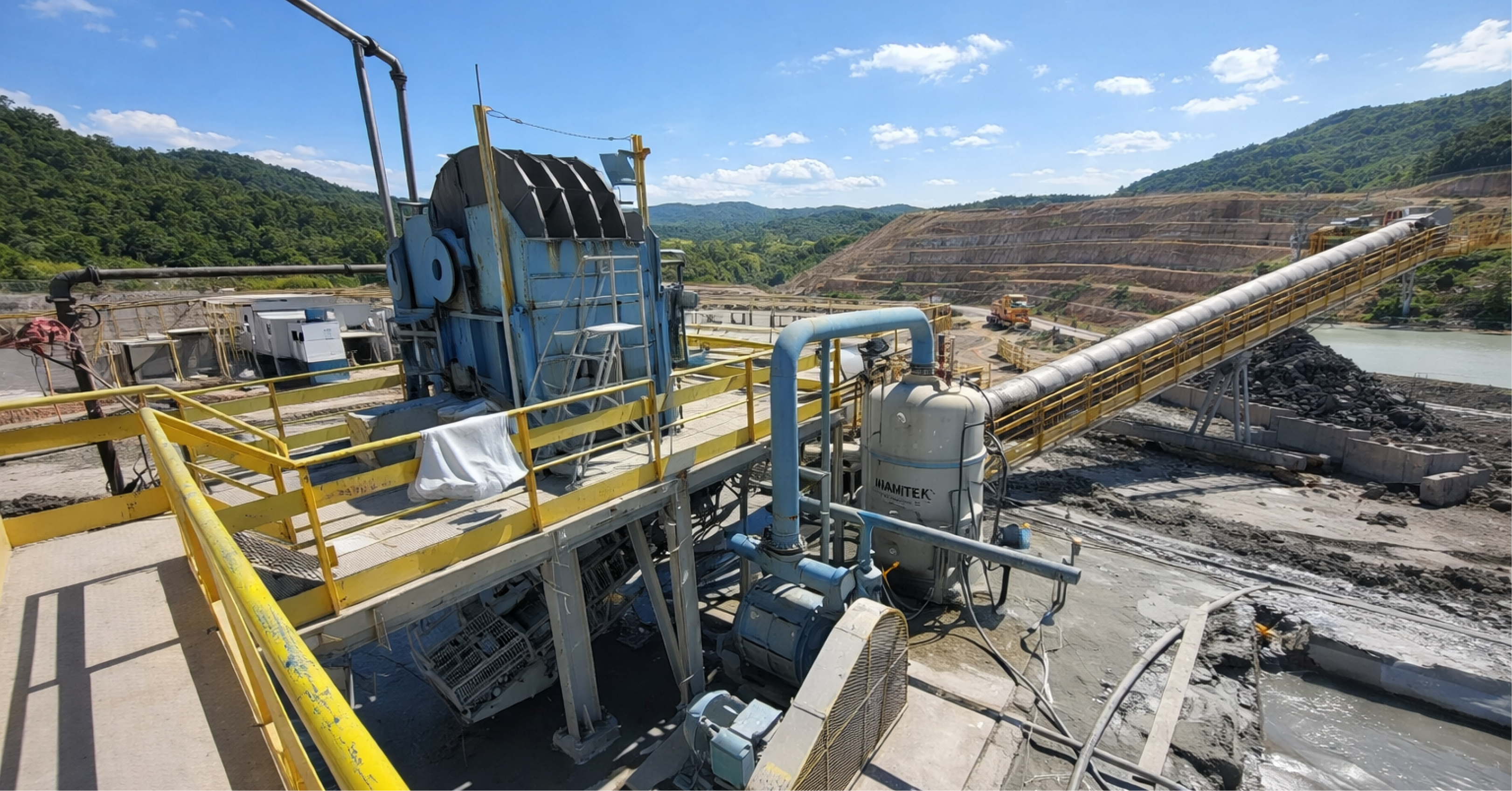
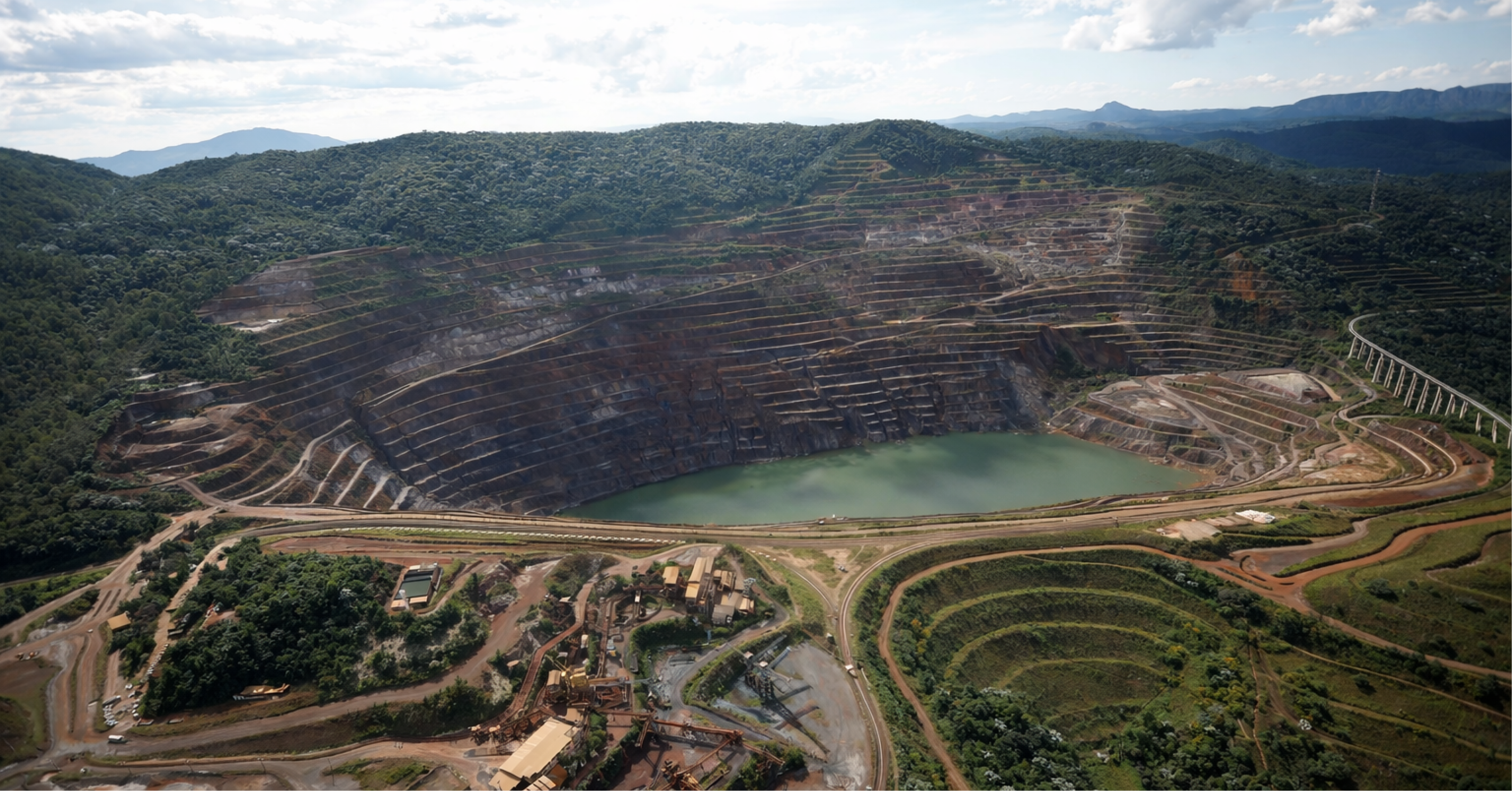
InSAR simultaneously addresses three historical constraints of mining: the scale of assets, access to critical areas, and the analytical capacity to monitor complex structures with lean teams. Tailings dams, waste rock piles, pits, and associated infrastructure are distributed across large areas, often in remote regions that are difficult or dangerous to access. Point-source instrumentation is indispensable, but it cannot, on its own, capture the complete spatial behavior of these structures.
By combining broad spatial coverage, millimeter-level sensitivity to deformation, and remote acquisition, InSAR enables the monitoring of dams, tailings piles, pit slopes, abutments, and critical infrastructure within a single data grid. It reveals trends that would go unnoticed in point inspections and creates historical series that support risk discussions in executive committees and forums with external stakeholders.
For this reason, InSAR frequently appears in ESG dashboards, annual reports, and investor presentations. It is not merely a technical tool, but an element of the corporate narrative of responsibility and due diligence.
Integration into the risk management cycle and into the “three lines of defense"
From the perspective of the "three lines of defense," the role of InSAR can be viewed in a structured way. In the first line, operations and geotechnics use InSAR to monitor the daily performance of structures, prioritize inspections, identify settlement and deformation trends, and adjust field routines. In the second line, risk management and dam safety incorporate... dashboards InSAR reports serve as objective evidence of ongoing monitoring, input for risk matrices, and support for action plans. Thirdly, internal and external audits utilize historical InSAR data as part of the audit trail, assessing what was visible before an event, what anomalies were recorded, and what decisions were or were not made.
InSAR, therefore, is not just a sophisticated sensor. When properly framed, it transforms into a governance asset, connected to clear responsibilities, formal processes, and documents that record how the data is analyzed and incorporated into decision-making.
Fundamentals of InSAR applied to containment structures
What does InSAR measure and what does that mean in geotechnical terms?
From a physical standpoint, InSAR compares the phase of the radar signal recorded by a satellite on different dates. The phase difference is interpreted as a variation in distance along the line of sight, which is then converted into displacement.
For the engineer, this means that each coherent point behaves like a “virtual landmark”, with a time series of accumulated displacement. This displacement is projected onto the satellite's line of sight; that is, it is a combination of vertical and horizontal components. Geotechnical interpretation requires an understanding of the geometry of the ascending and descending orbit, and the topography of the monitored area.
From a stability perspective, the interpretation of InSAR needs to be connected to concrete questions. It is necessary to assess whether what is observed is settlement due to consolidation, progressive plastic displacement, or simply elastic adjustment of the rock mass. It is essential to inquire whether the pattern is compatible with the behavior expected by the design and numerical models, or whether it suggests an uncaptured mechanism. It is equally important to distinguish whether the behavior is localized, indicating a possible defect or weak zone, or distributed, pointing to a global change in stiffness or a change in water level.
Without this bridge between observed deformation and behavioral hypotheses, InSAR remains on a descriptive level, without transforming into an explanatory and decision-making tool.
Temporal resolution, viewing geometry, and coherence: three structural constraints
A serious evaluation of the use of InSAR in dams must explicitly address three fundamental dimensions: temporal resolution, viewing geometry, and backscatter coherence.
Temporal resolution defines the interval between acquisitions and, consequently, the granularity with which the evolution of movements is monitored. Slow processes, such as settlement due to consolidation or progressive deformations, tend to be well captured. However, very fast processes, associated with sudden collapses, can occur between two passes, generating little useful data or loss of coherence before the rupture. It is crucial to verify how the data behaves during critical periods, such as heavy rainfall, accelerated height increases, or significant operational changes.
The geometry of the line of sight, combined with the topography, determines which sections of the dam and abutments have a favorable line of sight and which remain systematically in shadow or distorted. It is necessary to map which regions have good visibility for the satellite and which are "hidden," including in areas of slopes, fragile abutments, or contact zones with the foundation, where stability is often of interest.
Backscatter coherence depends on surface conditions throughout the year. Vegetation, surface moisture, the presence of lakes, deposition cycles, and erosion all influence the maintenance of coherent points. It is necessary to monitor the rate of coherence loss in critical zones and recognize the risk that precisely the regions of greatest geotechnical interest may present intermittent or non-existent data.
Addressing these three dimensions from the planning stage avoids deploying InSAR in a way that is "hope mode"Hoping that it will reveal what it cannot consistently measure physically."
Where InSAR works well and where it fails.
High-value cases: when InSAR becomes a competitive advantage
In tailings dams, InSAR tends to generate consistent value when the geometry is favorable, with moderate slopes, a wide crest, and exposed abutments, and when the surfaces present suitable conditions, such as drained tailings, granular cover, and low vegetation. The existence of sufficient historical data to differentiate noise from trend and the explicit connection with hypotheses of geotechnical behavior further enhance the benefit.
In these contexts, companies can justify investment decisions in reinforcements or construction based on observational evidence, prioritize inspections and investigation campaigns in portfolios with dozens of structures, and demonstrate to boards, regulators, and communities that they are not operating in the dark, but with real visibility into the behavior of the structures over time.
Risk cases: Absence of data confused with absence of problem.
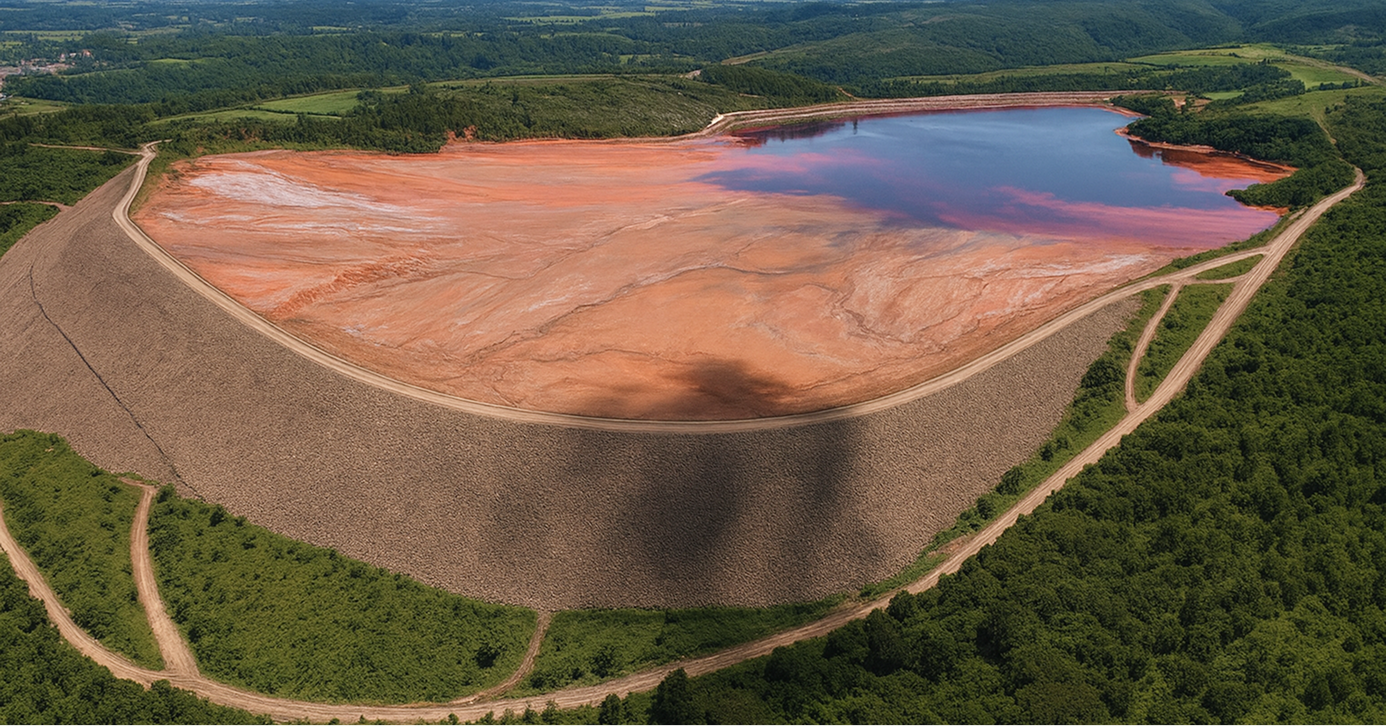
Risks arise when maps that appear to be "calm"These limitations conceal the physical constraints of the technology. This is the case with very steep downstream slopes, facing unfavorable directions, with few or no measurements directly in the areas of greatest stability interest. It is also the case with reservoirs with significant water depth, where areas of greater liquefaction potential appear as regions lacking coherence, rather than as stable regions. In abutments with dense vegetation cover, anomalies in the behavior of the embankment can be masked by variations in vegetation, humidity, or wind."
In these situations, a "clean" map easily leads to the misinterpretation that "where there is no signal, there is no risk." Responsible interpretation explicitly includes an InSAR visibility map, highlighting where there is robust data, where the data is intermittent or unreliable, and where there is simply no observation capability. The absence of data needs to be treated as a gap, not as evidence of stability..
Situations in which InSAR should not be the main player.
There are scenario classes where InSAR should be considered a complement and not the primary sensor. Failure modes governed by pore pressure and internal erosion, with little surface expression until advanced stages, require direct instrumentation. Rapid liquefaction events, where the window between apparently stable behavior and rupture is smaller than the revisit interval, limit the usefulness of InSAR series as a primary warning. Structures in a highly dynamic construction phase, with large geometric changes between acquisitions, also challenge direct comparisons between images.
In these cases, the monitoring design needs to be led by piezometry, structured inspections, internal instrumentation, and modeling, with InSAR playing a complementary role where and when it makes sense.
Integration with instrumentation and modeling
Evolving from a collection of sensors to a decision system.
Many operations already have multiple layers of monitoring. Piezometers, surface benchmarks, routine inspections, and independent surveys form an extensive dataset. The arrival of InSAR adds another layer and, without integration, tends to increase fragmentation: data in different systems, analyses conducted by separate teams, decisions dependent on individuals rather than processes.
The leap in maturity occurs when the company organizes all these elements as a decision-making system, in which each sensor has a defined role in relation to specific failure modes, data converges into integrated dashboards instead of isolated reports, and clear protocols transform readings into actions with deadlines and responsible parties.
InSAR, piezometry, GNSS and inspection: convergent reading
In practice, this means orchestrating readings in order to convergently answer the central questions of stability. An acceleration pattern in deformations observed in the InSAR in a downstream section gains relevance when it is accompanied by an increase in piezometric levels in adjacent sections, coincides with records of seepage, atypical moisture, or cracks in field inspections, and diverges from the behavior predicted by numerical models for that stage of operation. This set of factors strengthens the hypothesis of deterioration and justifies action.
On the other hand, an increase in displacement consistent with expected settlement in a region where piezometers indicate stable levels and there are no visual signs of deterioration can be classified as behavior within the design envelope, avoiding disproportionate reactions to isolated noises.
Maturity lies in prioritizing evidence, reducing the likelihood of normalizing early signs of deterioration, and at the same time preventing the system from producing a succession of false alarms that lead to fatigue and discredit.
Modeling as a common language between data and decision-making.
Well-constructed numerical models fulfill two complementary roles. First, they allow us to anticipate how slopes, foundations, and reservoirs should behave under different loading, drainage, and pore pressure development scenarios. Second, they provide a language for interpreting observed deformation patterns, connecting field and InSAR data to plausible physical mechanisms.
When time series and displacement fields obtained by InSAR are systematically compared with model results, the operation begins to function in a “feedback loop"Models inform expected behavior, field data refine the models, and updated models reduce uncertainty about the future and guide decisions more reliably."
Integrated panels and monitoring centers
In practice, this integration materializes in dashboards where InSAR, piezometers, GNSS, rainfall, reservoir levels, design states, and safety factors coexist in the same interface. The views are organized by structure, critical zone, and failure mode, allowing teams to navigate relevant topics, such as liquefaction or instability, and not just by sensor type.
Timelines of incidents and interventions connect rainfall events, construction work, operational changes, and emergency actions to the responses observed in the sensors. Within this ecosystem, InSAR ceases to be an external report and becomes a living component of routine geotechnical decision-making.
From color map to decision.
Framing InSAR from the conception of the plans
A recurring mistake is treating InSAR as a technological add-on contracted after the monitoring and action plans have been defined. This approach means that the data arrives without a clear place in the decision-making flow. The most effective way to avoid this problem is to define the role of InSAR during the planning phase.
Within this framework, it is necessary to define for which failure modes InSAR will be considered sensitive and relevant, which derived indicators will be used, such as velocity, acceleration, spatial extent of anomalies, and proximity of elements exposed to damage, and how these indicators will feed risk matrices, safety reports, executive dashboards, and action plans. The result is a coherent design, in which the data enters the system already with a defined function.
Triggers, alert levels, and the "right to not act"
A mature InSAR-based trigger system exists to organize decision-making, not to produce excessive alarms. It combines quantitative criteria, such as velocity variation relative to... baseline, sustained acceleration across multiple acquisition cycles and growth of the affected area, with qualitative criteria such as consistency with other data, operational context, and local reliability of the measurement itself.
Based on this combination, gradual response levels are defined, ranging from situations where intensifying monitoring is sufficient to scenarios that require operational restrictions, reinforcement works, or activation of emergency plans.
An important point is the explicit recognition of the “right not to act.” In some situations, an alert is analyzed, discussed, and documented, and, based on technical evidence, the conscious decision is made not to intervene at that time. This record protects the organization against impulsive decisions, while also ensuring traceability for future reviews and audits.
Protocols, governance and accountability
Converting data into decisions requires more than just technical expertise. It demands governance. Clear roles must be established, defining who receives the alert, who interprets it, who recommends, and who decides. Deadlines must be set for anomaly analysis, operational response, and escalation to risk committees or senior leadership, depending on the case's criticality. It is also essential to define how analyses are recorded, how decisions are archived, and how this information is revisited in review cycles and independent audits.
When InSAR is integrated into a system with this level of discipline, it ceases to be the responsibility of an individual or a supplier and becomes part of an institutional line of defense.
How VinQ transforms InSAR into a decision lever.
Today, most companies find themselves in one of three situations. Some still don't use InSAR, but are under increasing pressure to modernize their monitoring and demonstrate diligence to regulators and stakeholders. Others have already contracted services, receive reports and maps regularly, but realize that the connection to routine decision-making is still weak. There are also those that use InSAR in a localized way, with good results in specific instances, but without full integration into corporate risk governance.
VinQ operates precisely in the transition between available technology and effective value in decision-making.
Strategy and feasibility: deciding where and how InSAR makes sense.
In the strategic phase, VinQ supports operations in mapping the infrastructure portfolio and identifying where InSAR is critical, where it is complementary, and where it adds little value. It assesses temporal and spatial resolution requirements consistent with failure modes and the organization's risk appetite. From there, it helps to technically specify InSAR services, avoiding both under-dimensioning and over-sophistication that does not translate into decisions.
The result is a clear business case, in which investment in InSAR is directly linked to the decisions that the technology is intended to support.
Integrated interpretation: satellite data, instrumentation, and models
In the operational phase, VinQ does not compete with InSAR providers. It leverages the value of the data that the operation already receives. This involves critically reading maps, time series, and indicators provided by the providers, integrating with conventional instrumentation and numerical modeling in use at the mine, and constructing technical narratives that connect observation, hypothesis, risk, and action recommendations.
In this way, internal teams stop acting as passive consumers of reports and assume the role of technical orchestrators, with the autonomy and judgment to question, refine, and use the data in a consistent manner.
Designing dashboards and workflows for monitoring centers.
VinQ also supports the design and implementation of geotechnical monitoring centers and decision dashboards, focusing on integrating InSAR data with other sources in a common language. Visualizations are organized by structure, critical zone, and failure mode. Alerts are linked to workflows with defined responsibilities, analysis deadlines, and decision logs.
The goal is not just to add screens or graphs, but to create better risk communication between geotechnics, operations, risk management, and senior leadership.
Capacity building and cultural change
Finally, VinQ works on building internal capacity through training for geotechnical and operational engineers on applied InSAR interpretation, workshops with leadership on the role of advanced data in risk governance, and review of internal procedures to incorporate InSAR into monitoring plans, safety reports, and risk committee routines.
If your operation is somewhere on the journey between not using InSAR and extracting consistent decision-making value from this technology, VinQ can support you in defining the strategy, designing the decision architecture, and integrating satellite data into your risk governance system.
In simpler terms, if you already receive InSAR maps but are still unable to clearly connect them to the decisions you make about your tailings dams, VinQ can help transform that data into a true technical, operational, and institutional line of defense.
Authors:

John Paul dos Santos
Bachelor in Mining Engineering (UFMG), Master in Civil Engineering and Management (University of Glasgow), Specialist in Geotechnical Engineering and Project Management.
Mining Engineer specializing in geotechnics and project management, an international reference in dams and geotechnical structures applied to mining.

Matheus Vicentini
Civil Engineer (Unilavras), Specialist in Geotechnical Engineering (PUC Minas).
Civil Engineer with experience in geotechnics applied to mining, with experience in projects, audits and dam decommissioning works.